Gulf Coast
11 articles
Latest Gulf Coast articles
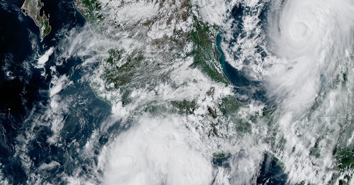
Tropical Storm Isaias Forecast Discussion Number 5
Issued at 400 PM CDT Wed Oct 07 2026 592 WTNT44 KNHC 072049 TCDAT4 Tropical Storm Isaias Discussion Number 5 NWS National Hurricane Center Miami FL AL092026 400 PM CDT Wed Oct 07 2026 Satellite and aircraft data show that Isaias continues to strengthen. GOES-19 imagery indicates that a central dense overcast has formed, and the system has become more symmetric than this morning. The peak NOAA Hurricane Hunter aircraft 700-mb winds were 61 kt, with the pressure dropping to 994 mb. The initial intensity is set to 55 kt as a reflection of this data. Isaias is basically on track, moving east-northeast at 7 kt. There is no change to the synoptic reasoning as a deepening trough along the northwestern Gulf Coast and a strengthening Atlantic subtropical ridge should cause the system to move faster to the northeast tomorrow and northward on Friday. As long as the cyclone remains intact, it makes physical sense that the system will move on the faster and eastward side of the guidance due to the stronger shear Isaias should encounter near landfall. Thus, the new forecast is adjusted slightly to the east, closer to the AI-based and corrected-consensus models. NOAA radar data (P3-TDR) show that the system is experiencing some southwesterly shear, with tilt analyses displaying the mid-level circulation displaced 5-10 n mi to the northeast of the low-level center. This structure seems sufficient for further intensification given a continuation of similar low or moderate shear and very warm SSTs in a very humid environment. Models are fairly consistent about the shear increasing on Friday, but almost all guidance still shows a category 1 or 2 hurricane at landfall. While the regional hurricane models have generally come down on the peak intensity this cycle, it is unknown whether this is the start of a real trend, and we would prefer to see more than one guidance cycle before making any adjustments. The new forecast is close to the previous one, near the high side of the model suite. Key Messages: 1. Isaias is expected to strengthen and be a strong hurricane when it approaches the northern Gulf Coast on Friday. There is an increasing risk of life-threatening storm surge along portions of the northern Gulf Coast, and a Storm Surge Watch is in effect from The Mouth of the Mississippi River to Yankeetown, Florida. Residents in the watch area should follow advice given by local officials and evacuate if told to do so. 2. The risk of damaging hurricane-force winds is increasing over portions of the Florida Panhandle, southern Alabama, and southern Mississippi. A Hurricane Watch has been issued from Bay St. Louis, Mississippi, to Indian Pass, Florida. Residents in these areas should prepare for the possibility of long-duration power outages. 3. Isaias will bring areas of heavy rainfall to the central U.S. Gulf Coast and much of the Southeast Friday into the weekend. Flash and urban flooding, along with isolated river flooding, will be possible. 4. Isaias could bring gusty winds and areas of heavy rain to the western portion of the Yucatan Peninsula through Thursday. FORECAST POSITIONS AND MAX WINDS INIT 07/2100Z 22.7N 92.9W 55 KT 65 MPH 12H 08/0600Z 23.1N 91.8W 70 KT 80 MPH 24H 08/1800Z 24.1N 90.1W 80 KT 90 MPH 36H 09/0600Z 25.8N 88.7W 90 KT 105 MPH 48H 09/1800Z 28.1N 87.6W 95 KT 110 MPH 60H 10/0600Z 31.0N 87.3W 60 KT 70 MPH...INLAND 72H 10/1800Z 34.0N 87.5W 30 KT 35 MPH...POST-TROP/INLAND 96H 11/1800Z 37.5N 84.5W 15 KT 15 MPH...POST-TROP/INLAND 120H 12/1800Z...DISSIPATED $$ Forecaster Blake
 Oct 7, 2026 · byNational Hurricane Center
Gulf Coast braces for impact from ‘strong hurricane’ Isaias
Several major events were canceled or threatened by Tropical Storm Isaias, which is expected to strengthen before landfall Friday.

Supertanker chartered from Gulf Coast to China for $76 million, 10 times higher than pre-war level
Shipping costs have exploded as the war in the Persian Gulf has led to a shortage of available tankers.
Tropical Storm Isaias Public Advisory Number 4
Issued at 1000 AM CDT Wed Oct 07 2026 000 WTNT34 KNHC 071453 TCPAT4 BULLETIN Tropical Storm Isaias Advisory Number 4 NWS National Hurricane Center Miami FL AL092026 1000 AM CDT Wed Oct 07 2026 ...HURRICANE AND STORM SURGE WATCHES ISSUED FOR PORTIONS OF THE NORTHERN GULF COAST FOR STRENGTHENING ISAIAS... SUMMARY OF 1000 AM CDT...1500 UTC...INFORMATION ----------------------------------------------- LOCATION...22.4N 93.6W ABOUT 260 MI...420 KM WNW OF PROGRESO MEXICO ABOUT 540 MI...870 KM SSW OF THE MOUTH OF THE MISSISSIPPI RIVER MAXIMUM SUSTAINED WINDS...45 MPH...75 KM/H PRESENT MOVEMENT...ENE OR 70 DEGREES AT 8 MPH...13 KM/H MINIMUM CENTRAL PRESSURE...1000 MB...29.53 INCHES WATCHES AND WARNINGS -------------------- CHANGES WITH THIS ADVISORY: A Storm Surge Watch has been issued from the Mouth of the Mississippi River eastward to Yankeetown, Florida. A Hurricane Watch has been issued for the northern Gulf Coast from Bay St. Louis, Mississippi to Indian Pass, Florida. A Tropical Storm Watch has been issued for the northern Gulf Coast from the Jefferson/Plaquemines Parish line, Louisiana to west of Bay St. Louis, and from east of Indian Pass to Aucilla River, Florida. SUMMARY OF WATCHES AND WARNINGS IN EFFECT: A Storm Surge Watch is in effect for... * Mouth of the Mississippi River to Yankeetown A Hurricane Watch is in effect for... * Bay St. Louis to Indian Pass A Tropical Storm Watch is in effect for... * Jefferson/Plaquemines Parish line to west of Bay St. Louis * East of Indian Pass to Aucilla River A Storm Surge Watch means there is a possibility of life- threatening inundation, from rising water moving inland from the coastline, in the indicated locations during the next 48 hours. For a depiction of areas at risk, please see the National Weather Service Storm Surge Watch/Warning Graphic, available at hurricanes.gov. A Hurricane Watch means that hurricane conditions are possible within the watch area. A watch is typically issued 48 hours before the anticipated first occurrence of tropical-storm-force winds, conditions that make outside preparations difficult or dangerous. A Tropical Storm Watch means that tropical storm conditions are possible within the watch area, generally within 48 hours. Interests in the Yucatan Peninsula of Mexico and elsewhere around the U.S. northern Gulf Coast should closely monitor the progress of this system. Additional watches and warnings could be required for a portion of the U.S. northern Gulf coast later today. For storm information specific to your area, including possible inland watches and warnings, please monitor products issued by your local National Weather Service forecast office. DISCUSSION AND OUTLOOK ---------------------- At 1000 AM CDT (1500 UTC), the center of Tropical Storm Isaias was located by an Air Force Reserve Hurricane Hunter aircraft near latitude 22.4 North, longitude 93.6 West. Isaias is moving toward the east-northeast near 8 mph (13 km/h). A continued east-northeastward motion is expected today, followed by a turn toward the northeast and north on Thursday and Friday. On the forecast track, Isaias is expected to pass to the north of the Yucatan Peninsula on Thursday and approach the U.S. northern Gulf Coast on Friday. Maximum sustained winds have increased to near 45 mph (75 km/h) with higher gusts. Rapid strengthening is forecast over the next day or two, and Isaias is expected to become a hurricane by Thursday. Tropical-storm-force winds extend outward up to 45 miles (75 km) from the center. The estimated minimum central pressure is 1000 mb (29.53 inches) based on Air Force dropsonde data. HAZARDS AFFECTING LAND ---------------------- Key messages for Isaias can be found in the Tropical Cyclone Discussion under AWIPS header MIATCDAT4 and WMO header WTNT44 KNHC. STORM SURGE: The combination of a dangerous storm surge and the tide will cause normally dry areas near the coast to be flooded by rising waters moving inland from the shoreline. The water could reach the following heights above ground somewhere in the indicated areas if the peak surge occurs at the time of high tide... Ocean Springs, MS to Indian Pass, FL...5-7 ft Mobile Bay...5-7 ft Mouth of the Mississippi River, LA to Ocean Springs, MS...3-5 ft Indian Pass, FL to Aucilla River, FL...3-5 ft Aucilla River, FL to Yankeetown, FL...2-4 ft Lake Pontchartrain...1-3 ft The deepest water will occur along the immediate coast near and to the east of the landfall location, where the surge will be accompanied by large and dangerous waves. Surge-related flooding depends on the relative timing of the surge and the tidal cycle, and can vary greatly over short distances. For information specific to your area, please see products issued by your local National Weather Service forecast office. For a complete depiction of areas at risk of storm surge inundation, please see the National Weather Service Peak Storm Surge Graphic, available at hurricanes.gov/graphics_at4.shtml?peakSurge. WIND: Hurricane conditions could begin in the Hurricane Watch area late Friday, and tropical storm conditions could begin in the watches areas midday Friday. Gusty winds are possible in portions of the Yucatan Peninsula on Thursday. RAINFALL: Tropical Storm Isaias is expected to produce rainfall amounts of 2 to 4 inches through Thursday across coastal portions of the Bay of Campeche with isolated higher amounts possible in the states of Campeche and western Yucatan. From Friday through the weekend, the system is expected to produce rainfall amounts of 3 to 6 inches, with localized totals up to 10 inches, across the central U.S. Gulf Coast extending from far southeastern Louisiana to the Florida Panhandle. Rainfall amounts of 1 to 3 inches, with localized amounts up to 5 inches, are possible across much of the Southeast as far north as the Tennessee Valley and the Carolinas. Flash and urban flooding, along with isolated river flooding, will be possible. For a complete depiction of forecast rainfall associated with Tropical Storm Isaias, please see the National Weather Service Storm Total Rainfall Graphic available at hurricanes.gov/graphics_at4.shtml?rainqpf and the Flash Flood Risk graphic at hurricanes.gov/graphics_at4.shtml?ero SURF: Swells are expected to affect the western and northern portions of the Yucatan Peninsula beginning on Thursday and spread northward toward the Gulf Coast late this week. These swells are likely to cause life-threatening surf and rip current conditions. Please consult products from your local weather office. A depiction of rip current risk for the United States can be found at: hurricanes.gov/graphics_at4.shtml?ripCurrents NEXT ADVISORY ------------- Next intermediate advisory at 100 PM CDT. Next complete advisory at 400 PM CDT. $$ Forecaster Blake
Oct 7, 2026 · byNational Hurricane CenterTropical Storm Isaias Public Advisory Number 3
Issued at 400 AM CDT Wed Oct 07 2026 000 WTNT34 KNHC 070852 TCPAT4 BULLETIN Tropical Storm Isaias Advisory Number 3 NWS National Hurricane Center Miami FL AL092026 400 AM CDT Wed Oct 07 2026 ...DEPRESSION BECOMES TROPICAL STORM ISAIAS... ...FORECAST TO RAPIDLY STRENGTHEN OVER THE NEXT COUPLE OF DAYS... SUMMARY OF 400 AM CDT...0900 UTC...INFORMATION ---------------------------------------------- LOCATION...22.0N 94.1W ABOUT 285 MI...460 KM W OF PROGRESO MEXICO ABOUT 580 MI...935 KM SW OF THE MOUTH OF THE MISSISSIPPI RIVER MAXIMUM SUSTAINED WINDS...40 MPH...65 KM/H PRESENT MOVEMENT...ENE OR 75 DEGREES AT 8 MPH...13 KM/H MINIMUM CENTRAL PRESSURE...1004 MB...29.65 INCHES WATCHES AND WARNINGS -------------------- There are no coastal watches or warnings in effect. Interests in the Yucatan Peninsula of Mexico and the U.S. northern Gulf Coast should closely monitor the progress of this system. Hurricane Watches will likely be required for a portion of the U.S. northern Gulf coast later today. DISCUSSION AND OUTLOOK ---------------------- At 400 AM CDT (0900 UTC), the center of Tropical Storm Isaias was located near latitude 22.0 North, longitude 94.1 West. Isaias is moving toward the east-northeast near 8 mph (13 km/h). A continued east-northeastward motion is expected today, followed by a turn toward the northeast and north on Thursday and Friday. On the forecast track, Isaias is expected to pass to the north of the Yucatan Peninsula on Thursday and approach the U.S. northern Gulf Coast on Friday. Maximum sustained winds have increased to near 40 mph (65 km/h) with higher gusts. Rapid strengthening is forecast over the next day or two, and Isaias is expected to become a hurricane by Thursday. Tropical-storm-force winds extend outward up to 45 miles (75 km) from the center. The estimated minimum central pressure is 1004 mb (29.65 inches). HAZARDS AFFECTING LAND ---------------------- Key messages for Isaias can be found in the Tropical Cyclone Discussion under AWIPS header MIATCDAT4 and WMO header WTNT44 KNHC. RAINFALL: Isaias is expected to produce rainfall amounts of 2 to 4 inches through Thursday across coastal portions of the Bay of Campeche with isolated higher amounts possible in the states of Campeche and western Yucatan. From Friday through the weekend, Isaias is expected to produce rainfall amounts of 3 to 6 inches, with localized totals up to 10 inches, across the northern U.S. Gulf Coast extending from far southeastern Louisiana to the Florida Panhandle. Rainfall amounts of 1 to 3 inches, with localized amounts up to 5 inches, are possible across much of the Southeast as far north as the Tennessee Valley and the Carolinas. Flash and urban flooding, along with isolated river flooding, will be possible. For a complete depiction of forecast rainfall associated with Isaias, please see the National Weather Service Storm Total Rainfall Graphic available at hurricanes.gov/graphics_at4.shtml?rainqpf and the Flash Flood Risk graphic at hurricanes.gov/graphics_at4.shtml?ero. WIND: Gusty winds are possible in portions of the Yucatan Peninsula on Thursday. SURF: Swells are expected to affect the western and northern portions of the Yucatan Peninsula beginning on Thursday and spread northward toward the Gulf Coast late this week. These swells are likely to cause life-threatening surf and rip current conditions. Please consult products from your local weather office. A depiction of rip current risk for the United States can be found at: hurricanes.gov/graphics_at4.shtml?ripCurrents NEXT ADVISORY ------------- Next complete advisory at 1000 AM CDT. $$ Forecaster Papin
Oct 7, 2026 · byNational Hurricane CenterTropical Depression Nine Public Advisory Number 2
Issued at 1000 PM CDT Tue Oct 06 2026 000 WTNT34 KNHC 070254 TCPAT4 BULLETIN Tropical Depression Nine Advisory Number 2 NWS National Hurricane Center Miami FL AL092026 1000 PM CDT Tue Oct 06 2026 ...TROPICAL DEPRESSION FORECAST TO QUICKLY STRENGTHEN... SUMMARY OF 1000 PM CDT...0300 UTC...INFORMATION ----------------------------------------------- LOCATION...22.1N 95.0W ABOUT 345 MI...555 KM W OF PROGRESO MEXICO ABOUT 605 MI...975 KM SW OF THE MOUTH OF THE MISSISSIPPI RIVER MAXIMUM SUSTAINED WINDS...35 MPH...55 KM/H PRESENT MOVEMENT...E OR 80 DEGREES AT 5 MPH...7 KM/H MINIMUM CENTRAL PRESSURE...1005 MB...29.68 INCHES WATCHES AND WARNINGS -------------------- There are no coastal watches or warnings in effect. Interests in the Yucatan Peninsula of Mexico and the U.S. northern Gulf Coast should closely monitor the progress of this system. DISCUSSION AND OUTLOOK ---------------------- At 1000 PM CDT (0300 UTC), the center of Tropical Depression Nine was located near latitude 22.1 North, longitude 95.0 West. The depression is moving toward the east near 5 mph (7 km/h). An east-northwestward motion is expected on Wednesday, followed by a turn toward the northeast and north on Thursday and Friday. On the forecast track, the depression is expected to pass to the north of the Yucatan Peninsula on Thursday and approach the U.S. northern Gulf Coast on Friday. Maximum sustained winds are near 35 mph (55 km/h) with higher gusts. Steady strengthening is forecast, and the depression is expected to become a tropical storm early Wednesday and a hurricane on Thursday. The estimated minimum central pressure is 1005 mb (29.68 inches). HAZARDS AFFECTING LAND ---------------------- Key messages for Tropical Depression Nine can be found in the Tropical Cyclone Discussion under AWIPS header MIATCDAT4 and WMO header WTNT44 KNHC. RAINFALL: Tropical Depression Nine is expected to produce rainfall amounts of 2 to 4 inches through Thursday across coastal portions of the Bay of Campeche with isolated higher amounts possible in the states of Campeche and western Yucatan. From Friday through the weekend, the system is expected to produce rainfall amounts of 3 to 6 inches, with localized totals up to 10 inches, across the central U.S. Gulf Coast extending from southeastern Louisiana to the Florida Panhandle. Flash and urban flooding, along with isolated river flooding, will be possible. For a complete depiction of forecast rainfall associated with Tropical Depression Nine, please see the National Weather Service Storm Total Rainfall Graphic available at hurricanes.gov/graphics_at4.shtml?rainqpf and the Flash Flood Risk graphic at hurricanes.gov/graphics_at4.shtml?ero. WIND: Gusty winds are possible in portions of the Yucatan Peninsula on Thursday. SURF: Swells are expected to affect the western and northern portions of the Yucatan Peninsula beginning on Thursday and spread northward toward the Gulf Coast late this week. These swells are likely to cause life-threatening surf and rip current conditions. Please consult products from your local weather office. A depiction of rip current risk for the United States can be found at: hurricanes.gov/graphics_at4.shtml?ripCurrents NEXT ADVISORY ------------- Next complete advisory at 400 AM CDT. $$ Forecaster Reinhart
Oct 7, 2026 · byNational Hurricane CenterTropical Depression Nine Public Advisory Number 1
Issued at 400 PM CDT Tue Oct 06 2026 000 WTNT34 KNHC 062038 TCPAT4 BULLETIN Tropical Depression Nine Advisory Number 1 NWS National Hurricane Center Miami FL AL092026 400 PM CDT Tue Oct 06 2026 ...TROPICAL DEPRESSION FORMS OVER THE GULF OF AMERICA... ...FORECAST TO STRENGTHEN QUICKLY... SUMMARY OF 400 PM CDT...2100 UTC...INFORMATION ---------------------------------------------- LOCATION...22.1N 95.6W ABOUT 380 MI...615 KM W OF PROGRESO MEXICO ABOUT 630 MI...1015 KM SW OF THE MOUTH OF THE MISSISSIPPI RIVER MAXIMUM SUSTAINED WINDS...35 MPH...55 KM/H PRESENT MOVEMENT...E OR 90 DEGREES AT 5 MPH...7 KM/H MINIMUM CENTRAL PRESSURE...1007 MB...29.74 INCHES WATCHES AND WARNINGS -------------------- There are no coastal watches or warnings in effect. Interests in the Yucatan Peninsula and the U.S. northern Gulf Coast should closely monitor the progress of this system. DISCUSSION AND OUTLOOK ---------------------- At 400 PM CDT (2100 UTC), the center of Tropical Depression Nine was located near latitude 22.1 North, longitude 95.6 West. The depression is moving toward the east near 5 mph (7 km/h) and an east to east-northeast motion is expected during the next couple of days. By Friday, a turn to the northeast is anticipated. On the forecast track, the depression is expected to pass to the north of the Yucatan Peninsula on Thursday, and approach the U.S. northern Gulf Coast on Friday. Maximum sustained winds are near 35 mph (55 km/h) with higher gusts. Steady strengthening is forecast, and the depression is expected to become a tropical storm by early Wednesday and a hurricane on Thursday. The estimated minimum central pressure is 1007 mb (29.74 inches). HAZARDS AFFECTING LAND ---------------------- Key messages for Tropical Depression Nine can be found in the Tropical Cyclone Discussion under AWIPS header MIATCDAT4 and WMO header WTNT44 KNHC. RAINFALL: Tropical Depression Nine is expected to produce rainfall amounts of 2 to 4 inches through Thursday across coastal portions of the Bay of Campeche with isolated higher amounts possible in the states of Campeche and western Yucatan. From Friday through the weekend, the system is expected to produce rainfall amounts of 3 to 6 inches, with localized totals up to 10 inches, across the central U.S. Gulf Coast extending from southeastern Louisiana to the Florida Panhandle. Flash and urban flooding, along with isolated river flooding, will be possible. For a complete depiction of forecast rainfall associated with Tropical Depression Nine, please see the National Weather Service Storm Total Rainfall Graphic available at hurricanes.gov/graphics_at4.shtml?rainqpf and the Flash Flood Risk graphic at hurricanes.gov/graphics_at4.shtml?ero. WIND: Gusty winds are possible in portions of the Yucatan Peninsula on Thursday. SURF: Swells generated by the depression are expected to affect the western and northern portions of the Yucatan Peninsula beginning on Thursday. These swells are likely to cause life-threatening surf and rip current conditions. Please consult products from your local weather office. A depiction of rip current risk for the United States can be found at: hurricanes.gov/graphics_at4.shtml?ripCurrents NEXT ADVISORY ------------- Next complete advisory at 1000 PM CDT. $$ Forecaster Cangialosi
Oct 6, 2026 · byNational Hurricane Center
Research collaboration helps Gulf Coast communities plan for the unpredictable
For communities along the Gulf Coast, hurricane season presents a recurring challenge: knowing when, where and how to evacuate before a major storm hits. To tackle this, researchers at Texas A&M University have spent more than a decade helping local, state and federal agencies develop clear, data-driven evacuation strategies.

High Freight Costs Push More U.S. LNG Toward Europe
Europe is currently benefiting from the closed arbitrage between the U.S. Gulf Coast and Asia and is taking more LNG supplies in possible relief from concerns about winter gas supply. The Atlantic-Pacific arbitrage is closed for the rest of this year, due to high shipping costs, and this has led to a redirection of most U.S. spot cargoes toward Europe, where the freight costs are much lower. Over the past month, Europe has been drawing more LNG cargoes away from Asia, and deliveries to Europe have been only 4% lower than a year ago, compared to…

Corpus Christi Could Owe Texas $235M for Failed Desalination Plant
Heading into election season, leaders in Corpus Christi face a puzzling question: what to do with $235 million from the state of Texas for a seawater desalination plant that was never built. This month, officials in the Gulf Coast city declined to pursue the flagship water supply project for the second time in a year […]
 Sep 24, 2026 · byInside Climate News